- Printed on Regular Paper (32lb)
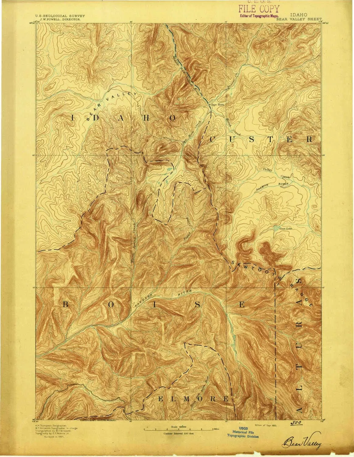
- USGS topographic map of Bear Valley, ID, at 1:125000 scale. High-quality paper print. Perfect for wall maps.
- Cities, towns, villages: Grandjean,Bear Creek Summer Home Area,Camp Creek Summer Home Area,Cape Horn (historical)
- Rivers, creeks: Vader Creek,Dodge Creek,McPhearson Creek,Bear Valley Creek,Bench Creek,Sack Creek,New Creek,Allen Creek,Bearskin Creek,Wolf Creek,Wyoming Creek,Hiyu Creek,South Fork Clear Creek,Burn Creek,Cub Creek,East Fork Elk Creek,West Fork Elk Creek,Spring Creek,Winnemucca Creek,Fox Creek,North Fork Elk Creek,Dry Creek,West Fork Creek,Crystal Creek,Newman Creek,Kettle Creek,Cook Creek,Chip Creek,McLeod Creek,Ayers Creek,McGown Creek,Canyon Creek,Jackson Creek,Marten Creek
- Lakes: Collie Lake,Rocky Lake,Lake Kathryn,Meadow Lake,Swamp Lake,Marten Lake,Red Mountain Lakes,Elizabeth Lake,Feather Lakes,Trail Creek Lakes,Alpine Lake,Elk Lake,Kelly Lake,Baron Lake,McGown Lakes,Cape Horn Lakes,Packrat Lake,Regan Lake,Baron Lakes,McWillards Lake,Trailer Lakes,F Eighty-Two Lake,Hanson Lakes,Blue Rock Lake,Warbonnet Lake
USGS topographic map of Bear Valley, Idaho, dated 1893.
Includes geographic coordinates (latitude and longitude), lines of elevation, bodies of water, roads, and more. This topo quad is suitable for recreational, outdoor uses, office applications, or wall map framing.
Printed on-demand by YellowMaps on the print material of your choice.
Shipping rolled from Minneapolis, MN, United States.
Product Number: USGS-5437190
Map Size: 20.2 inches high x 15.6 inches wide
Map Scale: 1:125000
Map Type: POD USGS Topographic Map
Map Series: HTMC
Map Version: Historical
Cell ID: 64964
Scan ID: 239449
Survey Year: 1891
Datum: Unstated
Map Projection: Unstated
Map published by United States Geological Survey
Map Language: English
Scanner Resolution: 600 dpi
Map Cell Name: Bear Valley
Grid size: 30 X 30 Minute
Date on map: 1893
Geographical region: Idaho, United States
Northern map edge Latitude: 44.5°
Southern map edge Latitude: 44°
Western map edge Longitude: -115.5°
Eastern map edge Longitude: -115°
Surrounding map sheets (copy & paste the Product No. in the search bar):
North: USGS-5432610,USGS-5436690,USGS-5436692
East: USGS-5437176,USGS-5433954,USGS-5437250,USGS-5437254,USGS-5433956
South: USGS-5437350,USGS-5437348,USGS-5437352,USGS-5430470,USGS-5437346
West: USGS-5437258,USGS-5433406,USGS-5437260


 Gangster Tote Bag")


